This is a PRIVATE website owned by John Skakel. Contact us HERE
Cemeteries Office Staff have asked that users NOT contact them with questions directly.
The Possible Lost Cemeteries
Located beside the Clover Leaf of 401 and Communication Road Interchange
Possibly a small part of the lost Community of Bridgend?
These areas must NOT be considered as fact until and unless proven differently in future
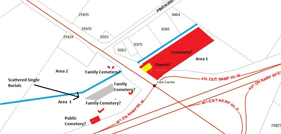
The POSSIBLE Lost Cemeteries at 401 and Communications Road.
Please note that the areas marked in red seem to be burial areas
However, until proven they must be considered susperct.
Yellow area may be Church as indicated.
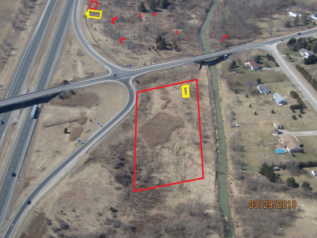
Photograph of intersection of Hwy 40 and 401 March 2013.
Red areas show possible burial locations. Small red dots indicate possible single burials.
Not all of these singles are shown. Please remember that it is not easy to find your way around down there,
so actual locations are approximate. When you actually walk in the area you can actually get somewhat
"Lost as to your position" very quickly. The yellow area indicates a possible old building.
Church maybe? Please remember that no archaeological excavations have been done here
so these areas are possible grave locations only
The following is available from Library and Archives, Canada
http://www.collectionscanada.gc.ca/databases/post-offices/001001-100.01-e.php
Name of Office: Brigend (or often mentioned as Bridgend)
Federal Electoral District: Kent (Ontario)
Dates:
Establishment Re-openings ...... Closings
1863-10-01 ..................... 1867-02-01
Postmaster Information:
Name of Postmaster ..... Date of Appointment ..... Date of Vacancy ..... Cause of Vacancy
Mrs. Anne Warner ....... 1863-10-01 .............. 1866-11-17 .......... Resignation - closed
Spring 2013, Paul Thorpe and John Skakel went out to the intersection of 401 and Hwy 40 (Communication Road) to do some investigation of reports of a cemetery there. More than one person had mentioned to the Kent branch of OGS apparently that they remembered seeing monument(s) standing in a cemetery there about the time that hwy 401 was punched through. We had very little to go on except that the memories seemed to point to them as being near to the creek. I can dowse so I brought a wire along and brought Paul so he could help to temporarily mark spots, and back me up in case someone came along to ask what we were doing on the unused 401 property.
Area 1. N side of Communications Road and 401.
The first area found was the largest one in Area 1. We quickly found that and investigated it over three days. We found what seemed to be a Communal Area, Kid's areas, and also interspersed possible burial and open plots. The possible location of a building surrounded by a cemetery and no burials within it's area highly suggest a former Church. Could this be a Church at the former community of Bridgend? No documentation of such a Church has been found but this area (If it is what it seems) would be VERY, VERY old! So such documentation not existing would not be impossible.
We will of course try to find out when and above all IF this cemetery existed. When it began. When it was last used. etc. Can we find such? It is VERY unlikely! But all we can do is to do our best and to make absolute certain that anyone who might dig in the area understands what it MIGHT be.
We caution that dowsing is NOT an exact science. This area certainly does look like a cemetery, but dowsing does not prove this 100%. Further investigations via research are still needed to make the link. These may or may not solve the mystery of this.
Area 2 on W side of Communications Road and 401.
Searching also found what is a likely burial area on the Western side in Area 2. There seem to be 6 "adult" size graves in one area and 6 graves of very young children (babies?) in another area near by. It is interesting that they are buried at right angles to each other if the dowsing is showing me the results properly. This is obviously a small family plot. One of what is likely an almost infinite number spread around the countryside when you take into consideration the early Chatham-Kent Farmers, and the fact that our Native friends have lived here for so long before us. You will notice that there are three small family plots in this area. All of them use the same pattern of adults interred in one direction side by side, and kids at 90 degrees to that as shown in the diagram.
Area 3 on W side of Communications Road and 401.
Since there was still one area not investigated here, we decided further investigation was necessary. The first thing we found were a number of possible scattered single graves. Since these are single we must consider them even more suspect, but we should also consider them as possible locations. We did not count them but it was about 6.
When almost finished we found the one possible family location closest to the intersection. This area has about 8 adult burials and 15 kids. We did not keep accurate counts as such is really meaningless without further information. Since we had found another we decided we should make one more pass closer to the highway, and quickly found the second possible family area further away from hwy 40. It has more like 4 adults and 4 kids. Lastly we found the larger possibly very early community area. This is a relative large area with a lot of shafts but with MANY blank spots indicating if it WAS a cemetery it was likely abandoned early. On a later occasion we found what could be a Church next to this last location. It was a large building for the time period, and has an entry door in the middle of it facing 401 that sticks out from the main building giving a very strong indication of a Church or a School there.
What are these?
We are told that one of these could be what has been called the "DeVries" burial ground. Not because people of that name have been buried there but because that is the name of the folks who reported remembering seeing it there. We are trying to find more information on that. Those who mentioned the site are no longer around to know of it.
Again, all of this must be considered suspect, but there are very strong indications of many burials in this area over a very long period of time. Since this could well be the end of what could have been a canoe link back to the Thames through a very deep drainage ditch, it is quite possible that burials in these areas could have began very early.
Unfortunately we can only give a whole lot of possibilities with this information at the moment. We wish we could give more, and we hope that there might be some possibility of further indications through research to verify some of this in the future.
Satellite Image of Area
https://maps.google.ca/maps/myplaces?ll=42.383338,-82.09406&spn=0.002952,0.005552&ctz=240&t=h&z=18