This is a PRIVATE website owned by John Skakel. Contact us HERE
Cemeteries Office Staff have asked that users NOT contact them with questions directly.
The lost Cemeteries of the Baldoon Area
The Old Baldoon (Dover Twp), Brown, McDonald-Snye
and Water Street Cemeteries (Chatham Twp)
With Thanks to The Stewart Family, Bob Dekoning, Dorothy McDonald, Henry Van Haren and Les Mancell, Information from Valley of the Lower Thames and Romantic Kent.
There are really four different cemeteries involved with the Baldoon Settlement(s). Even though these are not in the same municipality we thought it more appropriate to place them together here. Please note that these were NOT all began at the same time, but their usage did overlap. Some were used at similar times. Baldoon was more or less the first. Then Brown and McDonald, and Water Street were used at roughly the same time, and finally Riverview. There is some evidence of misinformation on Brown, and we are trying to solve that at the moment. There also seems to be a Murdock and Johnson (Johnston) Cemetery. Could it be the same but the correct name for Brown?
The Original Baldoon Cemetery in Dover Township.
Baldoon Cemetery:
Located on Snye Road in Dover. Not far from the bridge to Walpole island and on that side of the River.
We suspect that this was the first known grave yard used by the Baldoon folks when they arrived in that area. Lord Selkirk had gathered together 15 families who he had convinced to immigrate to Ontario where he had purchased 950 acres of land in north Dover Twp in Kent. County to form a settlement. They arrived in Sept. of 1804 when the weather was still mild and water levels low. Some settlers soon became ill due to the mosquitoes, poisonous insects, swamp vapours and poor management. Shelters that were supposed to have been built before their arrival was not done and they lived primarily in tents. Out of the 111 men, women and children that arrived here, 42 would die in the first year.
In a few short years they decided to move to higher ground a short distance away up the river. The site known today as the Baldoon Settlement.
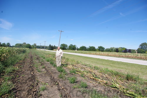
Our researcher Les Mancell tells us how he was able to find records of the cemetery location that was eventually found via dowsing...
Quote... "With the historic plaque moving about ... I started to focus on WHERE did they first settle. Dover Twp.
I found the 'Baldoon Farm' located in North Dover. It would seem that was the original Baldoon settlement.
I think I found a "Cemetery" marked on the map, in that area. It seemed not improbable that was the original cemetery.
So, this one was found via research, and then later the position was confirmed via dowsing it.
This grave yard has been destroyed and nothing is left of it. It is almost certain from records, position, etc that this IS the location even though it has been found via dowsing.
Brown Cemetery: Possible alternete name Murdock and Johnston?
Chatham Twp. - toward Walpole Island from the park.
There was a Stage 3 archaeological survey of this cemetery and it's surroundings done in 2003 by Mayer Heritage Consultants. A report to Council October 15, 2003 recommended municipal ownership of this wetland area and that it be called the Roberta Stewart Wildlife Area and Trail. Ducks Unlimited helped with the project. At that time there was work done to determine the actual location of the cemetery and it's boundaries adjacent to the trail. .
The area is now managed by the Wallaceburg Facility Supervisor.
We have been told that some members of the Stewart family provided much of the transcription of a few stones that they had record of. We thank them for having the foresight to do that for KOGS 30 some years ago. We have since been told by them that some monuments may be visible again, and we hope to provide more information on this in the spring of 2014 when good weather returns. We hope to be doing some photography of the site and monuments at that time. Please stay tuned.
We had been told (incorrectly) that the cemetery was no longer visible, and was not kept up but recent information proves that is not the case! In fact the Stewart family we are now told had been VERY careful to keep it up at their own expense for many, many, many years! Everyone should be Thankful that they took the time to do that and we DO thank them for that! Now it has, been turned over to the municipality.
Please Note that there is PRIVATE PROPERTY around the site and it should NOT be entered without permission from the adjacent farm owners! That is only courtesy to them!
See names of those buried in the Brown Cemetery.
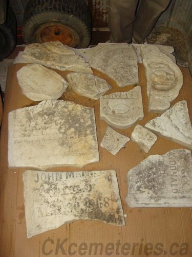
The few remaining monuments from the Old McDonald Family Cemetery
McDonald (Snye)Cemetery
The known graves in McDonald cemetery are dated between 1868 & 1885.
Located on St. Clair Parkway on opposite side of the road from the park.
Some pieces of the old stones still exist but are now available for public viewing in the Wallaceburg Museum.
The location of the old cemetery has been dowsed and fragments of monuments were found at original location. This location is NOT available for public viewing. It is on private property and You MUST ask for permission if you wish to access it!
A transcription document has the information from the stones when they were still standing years ago and the names are clearly seen on the fragments that are seen in the other pictures. The fragments of monuments that ended up in the creek were recovered by someone and turned over to the parkway. They had them stored in their yard in the dirt. They were discovered by Mr. Dekoning and brought to their current location where they would dry and be safer. We all owe Mr Dekoning a huge vote of Thanks as without his concern these old monument pieces would not exist!
There was apparently a Border City Star reel with a picture of the cemetery in situ ... but we do not have a copy of it now ... The photo was not of good quality
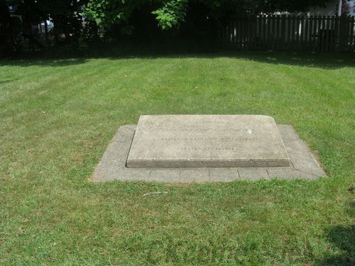
The Water Street Cemetery
McDougal (Water Street or Old Wallaceburg) Cemetery.
McDougall Cemetery stones were dated 1848 - 1885.
If you look at this link you will find information on that location. It was later destroyed as well with many monuments and burials being moved to the new Wallaceburg Riverview Cemetery. We have no information on how many remains if any are left at Water Street location. It is VERY likely that some will still be there. It may be that MANY are still there.
http://ckcemeteries.ca/miscwiki/index.php?n=Main.WallaceburgOld
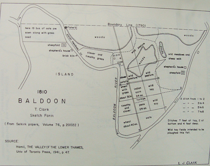
Map of original Baldoon Settlement.