This is a PRIVATE website owned by John Skakel. Contact us HERE
Cemeteries Office Staff have asked that users NOT contact them with questions directly.
The Field Cemetery
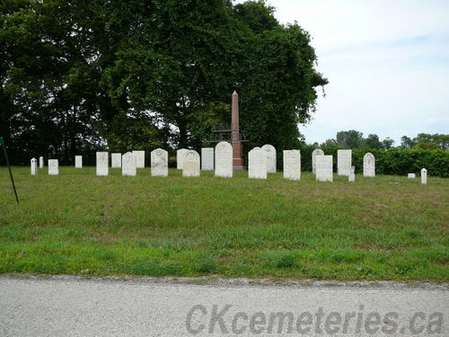
The NEW Field Cemetery. (Last Last known burial in 1932
Though used only occasionally after Bethel Cemetery replaced it.)
With Special Thanks to
Connie Grant and Jennifer Tedford
Much of the information on this web page was taken from the book entitled "The Story of Bethel", and the special insert called "Brick Bethel Church". We would like to thank the folks above for finding us a copy of that book and for helping us to put together the following information on the cemetery.
Please note that information here is the same as the introduction to the Bethel Cemetery.
See other photographs of the Field Cemetery area.
The Original Field School and Cemetery
Location - Nearest 911 number 11092 River Line.
It is thought that in it's early times, the history of these two cemeteries began near the banks of the Old River Thames, the main thoroughfare of the time. It is thought that there was both a house and a school down on the river's edge plus the "Original Field Cemetery". We do not know if that school might have served as a church as well. There is mention of the old mud floor, and of the school being used as a meeting house. Ashes were laying on the floor still smouldering left over from trying to keep the school warm. The teacher even simply tossed his/her left over tea onto the floor adding the tea leaves to the trash there. This building would have only existed for a short time, but we do NOT today know the time frame of it. It has been noted that the path to it from one direction passed through an Indian camp. The natives would place bodies in blankets and tie them tightly to branches of trees. Then remove them for another burial. And it is reported how terrified kids were to walk through that area. We caution that there seems to be some dispute as to whether or not this original school existed. The only thing that would prove it's existence would be sensing the old grave shafts. We do know that there was a native trail near the river due to the many arrow heads etc being found there, so this seems to give the story a lot of credence.
The New Field School and Cemetery
Location - Nearest 911 number 11092 River Line.
In a short time the cemetery was moved up hill to it's new location, and a new log building was apparently erected nearby. There is some confusion as to whether this school was across from the new Field Cemetery that we know today or near it on the same side of the road. We have found existence of a building directly across from the cemetery approximately 18 feet by 24 feet. It is said that they moved the cemetery and school from the previous location due to flooding. BUT if so they did not pick well, as they soon learned that this location flooded badly as well down at grave level even though it was so much higher. At burials water would often have to be baled out of the grave shafts with pales. The new building facing the new cemetery was used as a school through the week and a church on Sunday. Like the old building before it, this one had well packed dirt floors. It is known that the first train went through on what is now the CNR Railway (Then Great Western) in January of 1854. And the students in the school were standing right there on the Mull side road to watch it. The teacher had them walk down to see that historic event! Funerals and weddings were not generally held in this building as it was too small, so they were held in the homes instead. We do not know when this frame school was built, but we do know that the school was actually moved out of this building to a new location with a brick school on the corner of the River Line and Mull Side Road on the South Corner. The booklet states that it moved before 1867, probably around the 1850's. Thus it seems obvious that the building served only as a Church for a short period of time.
We have heard that some old ink wells were plowed up at one point in the immediate area where the church was documented to be located.
Please remember that sensing indicates that the road seems to have been moved slightly since this cemetery was located here. If you look at the old fence lines, you can see the angle of it's original borders. On the South corner, the road edge is approximately whee it would have been when the cemetery was in use. On the East corner, the cemetery seems to go right under the road, and over to road edge on the far side. Thus, you can place a line between these points showing the actual front of the cemetery. We have no documentation as to the time frame on when the road was moved.
Sensing indicates that there was a Potter's Field in the Cemetery along the South West (Chatham) side. Up front here is a large "Kid's area". This kid's area is very different from many too as it is not just babies but kids as well. The shafts are approximately 4 feet in length, so this is quite unusual for our area. Generally they are only three feet long indicating only babies. Since this one involves older kids too, the area is VERY large. Then just behind the kid's area running to the back seems to be a Potter's Field running parallel to that side fence. Remember that this area is along that fence, and NOT along the edge of the extension of the cemetery to the South West. There is also a large Potter's Field area on the South West (Chatham) side of the Extension on that side. This extension area indeed holds a LOT of burials over and above those in the main cemetery.
Later the Bethel Cemetery was opened near by in a much better location and the new Church and School were built.