This is a PRIVATE website owned by John Skakel. Contact us HERE
Cemeteries Office Staff have asked that users NOT contact them with questions directly.
Some History of The Old Ridgetown Cemetery
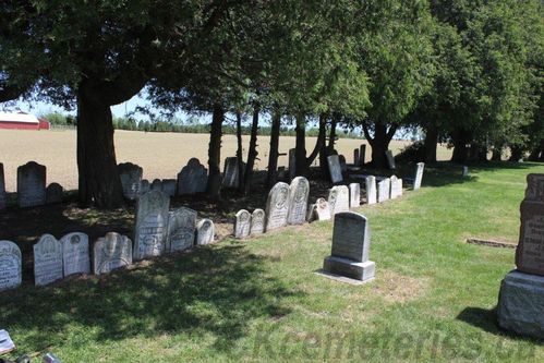
Notice the two lines of stones from the
Old Ridgetown Cemetery
In Greenwood Cemetery along
North East fence
Please Note that information here is Copyright of Tom Button, Ridgetown and this web site. No reproduction is allowed under any circumstances without permission! Also, With Thanks to Ridgetown Campus.

Second View of Old Stones
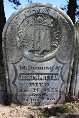
Monument of Joesph Mitton located
in row of stones from Old Cemetery
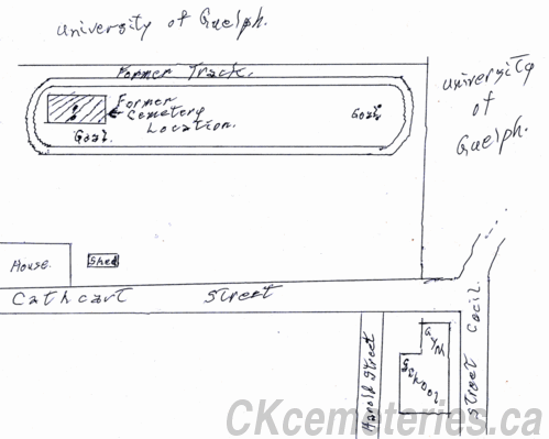
Diagram showing exact position of Old Ridgetown Cemetery 1852 - 1919
With Thanks to Dave Snobelen for Ground Penetrating Radar Work
The following diagram is a simple sketch to show the position of the Old Ridgetown Cemetery in regards to the High School running track, the soccer goal post, and the playing field in general. It is important that everyone notes that this is a simple sketch in relation to these points, and should not be taken as an accurate map of the area.
It should be noted that part of the playing field was once owned by the Ridgetown Campus. (At that time "Experimental Farm".) Then it was sold to allow the school to build their athletic field. This gave rise to the site being termed as being on "Experimental Farm" property. However, we believe it was right on the edge of it but not "On" their property. Thus the incorrect information that the cemetery was on "Experimental Farm" property began to circulate. Also, the cemetery had been removed before the Experimental Farm was began in 1922.
It is known that many stones disappeared at the time of cemetery being moved. (report puts it to be 51.) There is at least one side walk of a house nearby made of stones from that old cemetery. We have also had reports that the site was used as a location to obtain gravel, and as such small areas of the cemetery were infringed upon in old times.
The North West side of the cemetery seems to have been "Less Populated". This may well indicate that this was the Potter's Field area.
In 1885 graves began to be moved to the Greenwood site, and in 1919 it was decided to close the cemetery and move all interred to that site. Henry Spencer was hired to do the job, and it is written that he moved the remains from 137 graves.
All evidence now indicates that a "Double row of stones" on the North East side of Greenwood are stones that came from the old cemetery. A systematic inspection in the NEW cemetery indicates a series of shafts being dug there. Thus we now have reasonable indication that there are remains in that area. It is not known if these are the location of remains that have been moved from the old Cemetery. We DO know from history that the remains pertaining to each stone are NOT interred under them. Ridgetown area resident "Lloyd Mitton" knows that one stone from this line of monuments is to a relative who was interred in the Old Cemetery. There is also one possible reference that these stones lay flat piled up along the fence until summer of 1982 when they were moved to the present two line formation.
The Graves in the Old Ridgetown Cemetery
We do know that there were many stones stolen and moved from the old Cemetery.
In the basement of a house in Ridgetown is a stone noting a burial for Christian Willson who died in 1859. http://ckcemeteries.ca/miscwiki/index.php?n=Main.WillsonChristian .... This stone MAY have been located in the Old Cemetery before it was moved but we have yet to prove that.
See more photographs of the Monuments from Old Ridgetown Cemetery.
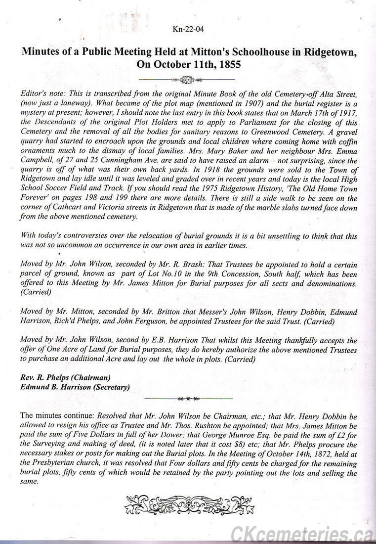
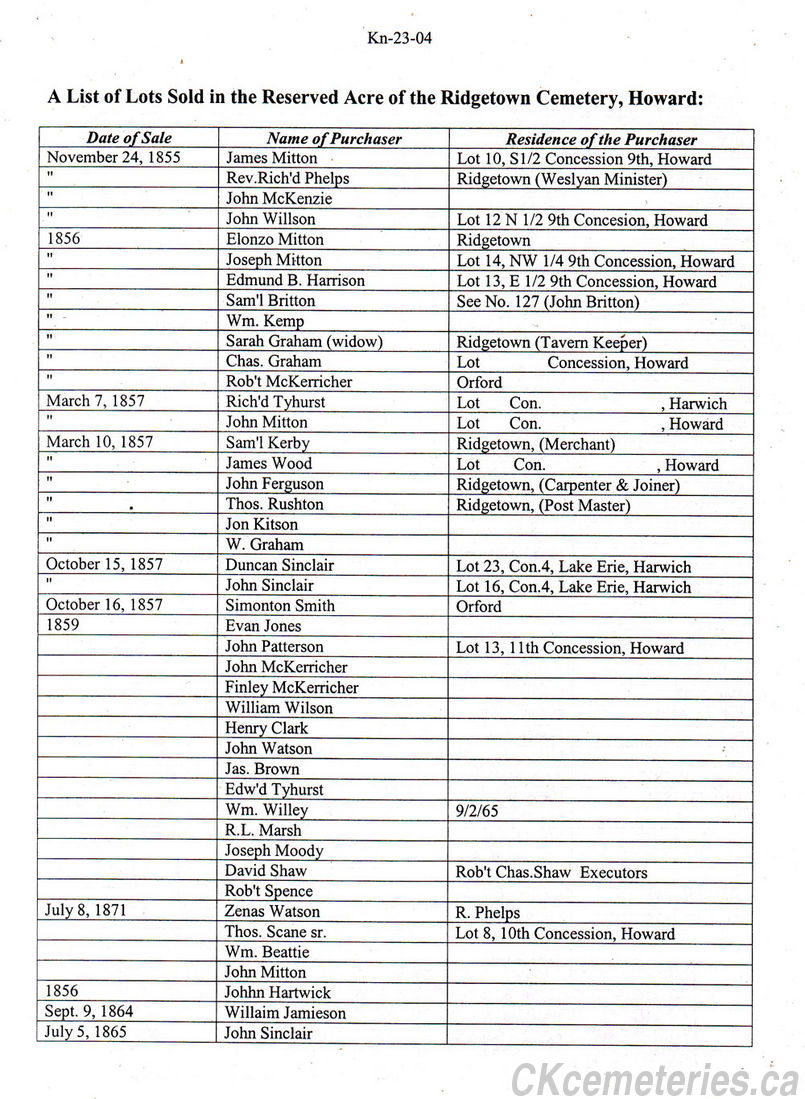
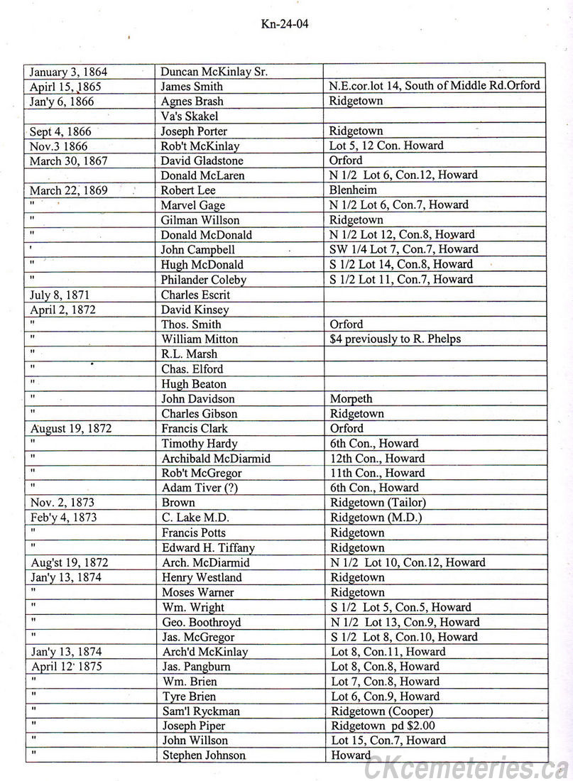
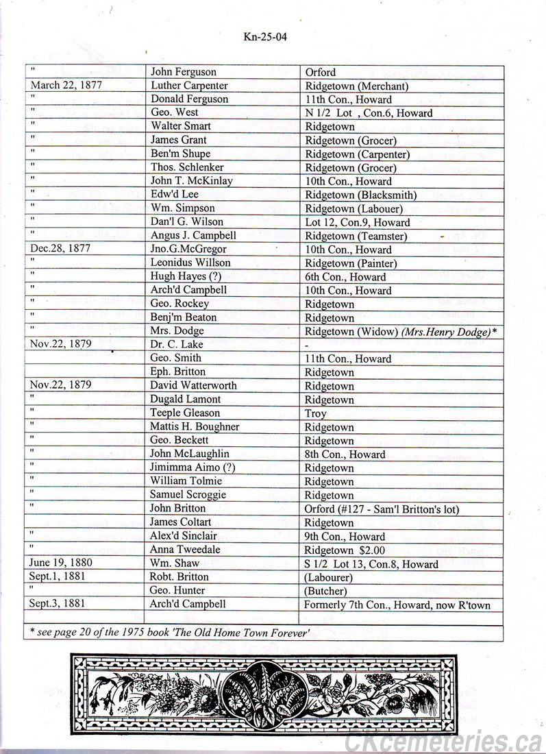
The Old Ridgetown Cemetery Book
(With thanks to O. K. and Carl Watson, Frank Vink and staff of Chatham-Kent Museum)
With Special Thanks to Kent Branch of OGS
Coloured pages printed with kind permission and help from the Chatham Kent Museum who now have the book in their posession.
The page photos of the book are copyright and may NOT be reproduced in any fashion without permission of C-K museum.
A Complete Copy of the Old Ridgetown Cemetery Records Book (Please Click)
In year 2001 a record book of some information on the Old Ridgetown Cemetery was found. If you click on the link just above, you will see copies of all pages of that record book. Be sure to note the records to it's formation, and how it was closed by an Act of Parliament. You will notice the names of families who bought plots, and the financial records page as well and the Potter's Field. It is well worth the time to read it. Also just below here you will see a modern typed version of a small portion of the records, and the names of the plot holders in clear type.
The following is a bit of information from the office of Kent Chapter of the Ontario Genealogical Society. There are some "Not pretty" things in it. So please do not read if you might be offended!
Copyright to KOGS
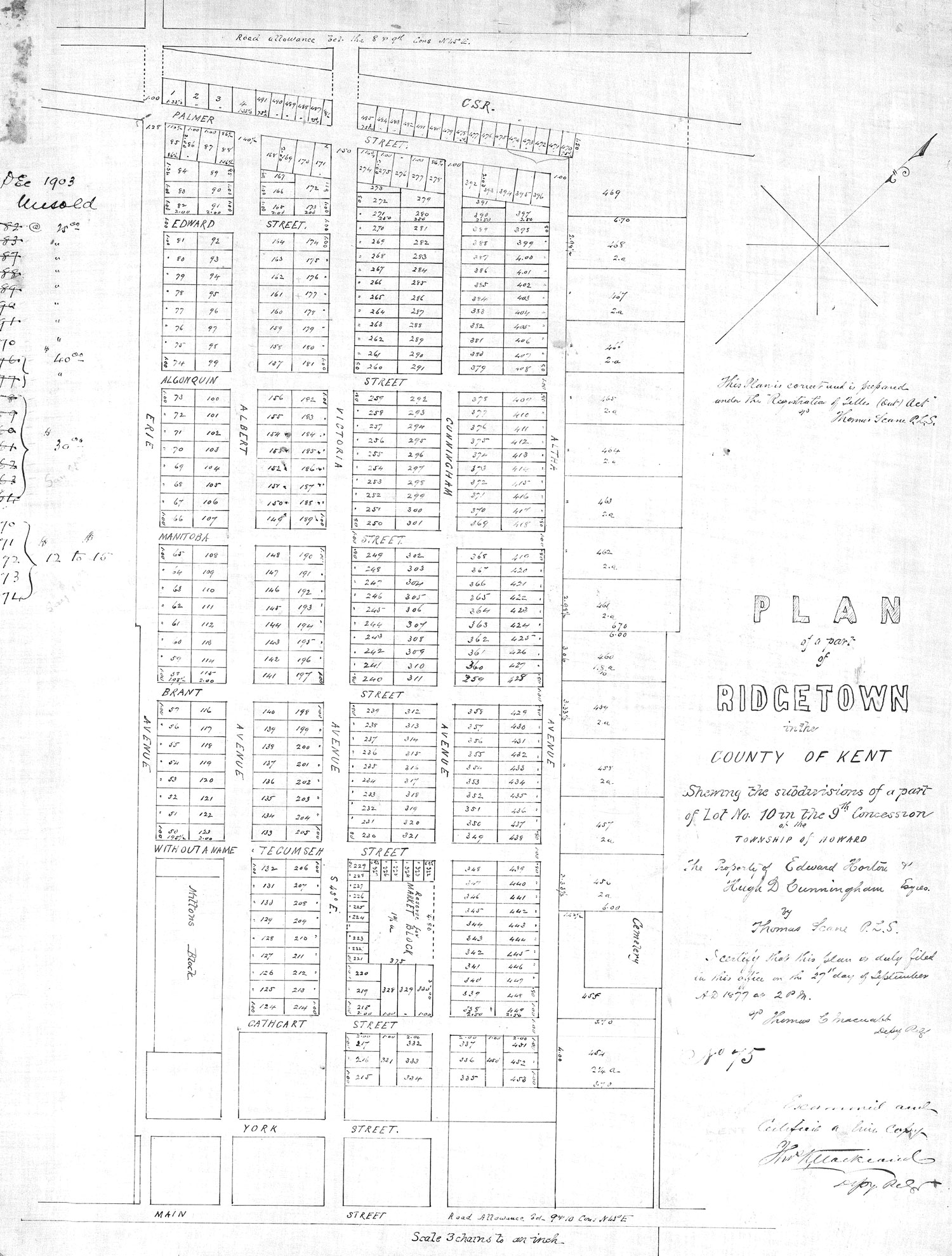
Below is Plan of North Quadrant of Town of Ridgetown - Date 1885
Showing location of Old Cemetery already present
Map below with Thanks to Rob, Carl, and OK Watson

The Old Ridgetown Cemetery Map
To obtain a file that can be used to reproduce a large original size version of this plan on paper please email me. John at CKCemeteries.ca (@ symbol in email replaced by word "At" to reduce spam.)
To view the map below in Larger format use Control + using Firefox or expand with similar commands using other browsers. To return to normal use Control 0 (zero).
Map Text
(Under direction Arrow) This Plan is correct and is prepared under the "Registration of (Titles?) Ontario Act".
Thomas Scane PLS (Public Land Surveyor?)
(Beneath That Text) Plan of a part of Ridgetown in the County of Kent Shewing the subdivisions of a part of Lot No 10 in the 9th Concession of the Township of Howard.
The Property of Edward Horton and Hugh D Cunningham (Esqes.?) by Thomas Scane P L S
I certify that this plan is duly filed in this office on the 27th day of September AD 1877 at 2 PM (?) Thomas C (Macnabb?) Depy (Re?)
1875
(Text under very unclear)(Examined?) and Certified a (?) Copy (Rest not readable)
Along bottom. Scale 3 chains to an inch. (Note by John Skakel, Wikipedia defines one chain as 66 feet or 22 yards).
Please note that along the LEFT side of the map some figures are missing. At top we believe the text to be Date 1903 Unsold. We believe the first number to be the plot number and the second to be the cost.
82, 83, 87, 88, 89, 90, 91, and 170 all at $25
176, 177 at $40
158, 159, 160, 161, 162, 163, 164 all at $30
And 470, 471, 472, 473, and 474, all at 12 to 15 dollars.
PLEASE NOTE that all of these are stroked off except the following. 170, 470, 471, 472, 473, 474. This SEEMS to indicate that all lots are sold at that time except for those 6 lots. This is interesting as many of those lots do not exist today, and those along Altha Street never seem to have been built. Also the larger lots along Altha Street on North East side show 2 A which probably would mean 2 a. Since 10 square chains equals an acre, the measurements back this up almost exactly.
At top of map you will see text
Road Allowance (bel?) the 8 and 9th cons N 45 degree E.
Just below CSR would probably indicate "Canada Southern Railway.
At bottom of map note text
Road Allowance (bel?) the 9 and 10th Cons N 45 degree E.
Please note the position of the Cemetery.