This is a PRIVATE website owned by John Skakel. Contact us HERE
Cemeteries Office Staff have asked that users NOT contact them with questions directly.
Tecumseh Park Confusing Information
Please note! We have pretty much proven that the strange pattern in the park is not burial related. However, there are two known military graves there and possibly others.
In mid June of 2012, we decided to do some dowsing in Tecumseh Park to see if we could find the same graves that others found there by our simple methods. However, what we found turned out to be extremely confusing. This is simply a temporary page to display findings until we can work through this.
When I began to do some "sensing" in Tecumseh Park, I was rather confused when I was sensing things everywhere. The whole park plus some areas further out shows what is a series of rows of what would seem to be old shafts just about three feet wide and 6 feet long. Side by side stretching across the park. They are parallel to the road. But run row after row from the old Armouries to the road behind the band shell and from the river to the road on the far side, and indeed in a large portion of that area it seems to extend right into the property on the other side. What makes it even more confusing is that I fo und one small area where the shafts are half size. Just like children's graves would look like. This break in the pattern is significant as it rules out many things that might make a constant pattern all of the way across.
We have no accounts of "White European" cemeteries in that area. And this area is so huge it would have to have been a cemetery for a very, very, very long time. It is doubtful that would have gotten lost. Could it have been Native in origin and existed before we "White Europeans" came on the scene? It seems rather unlikely as it would have not been likely to have ended on the exact front wall of the Old Armouries if that were the case! Also, the commercial Ground Penetrating Radar folks should have picked that up if there were graves there of any type.
I then went to Old St Paul's cemetery near by and did some sensing. Just to see if I got similar readings. i.e. something in my body was maybe causing this. Instantly I began to find the graves in Old St Paul's just like I would have been likely to and indeed, I seemed to even find two walls of the old church. That would seem to rule out this going back to my methods. I had not forgotten how to dowse.
I caution that no one should read too much into this at the moment. I would certainly NOT say that this means that there were hundreds upon hundreds of burials at one time in Tecumseh Park. What it does mean is that we should do more investigating to try to figure why I got these readings and to verify or explain them through GPR, others using the same sensing methods, etc. '''Most important we need to find out why the people who came in with GPR originally did not find a series of empty shafts like these at the time they wee here. The fact that they didn't makes my sensing almost impossible, but still. Why did I get that?
To see the area where I seemed to see the huge number of shafts of some sort please have a look at the map below. Each side that I found ended abruptly. The area did not gradually "die out"! It ended "With a bang" as they say in all cases. Please remember that some areas extend near or even into private property so I can only guess the location of the border in those locations.
Update June 13. The major problem in trying to "Decode this" is that the GPR hired to find the two or more graves thought to be on the site of those killed after the skirmish with natives at the creek mouth did not find any multiple grave shafts. Could this prove that my sensing is totally incorrect there? Or is there another explanation. After a lot of thought on this I have finally realized that the ground level of Tecumseh Park has quite possibly totally changed as you get closer to the river. Could this have been partially regraded upward at the time of the 1812 skirmish? Thus causing those graves to be higher than any older burials there? Or shafts put there for totally different reasons? If the ground level had been raised significantly could their GPR have gone right "Over top of" what ever is causing this pattern? Who knows. We probably NEVER will. However, I wanted to rule out Native burials so I called Walpole Island and talked with their historical people. I figured they would tell me I was totally wrong. And since there are no known European graves there that would end this. Instead I was told "This sounds right. Don't rule out this being Native". So, until I get further confirmation from our GPR/Dowsing expert, we are at a standstill. Please do not go around telling people we think we have found a huge Native grave yard. Chances are probably 9,999 to one against that.
Update June 14.
A suggestion by John Rhodes. One that finally makes sense
Just a suggestion; these might be latrines. Between 1838 and 1842 a rifle company was stationed in the park. About 100 men would have to answer nature's call once or twice per day. The "Outhouses" would have had to be within a short distance of the barracks which was located in the park from 1838 to 1880. A space 3' X 6' could host a two seater which would probably be the minimum accomodation for that many users. I doubt that the pits would have been dug more than a few feet deep and would fill fast. The next move would be to dig a new pit to the left or right, a few feet away, and start over. Over a period of four years, a great number of spots would have been used. Just a thought, maybe I am wrong.
Some things do not make sense on this, but it is certainly worth consideration. The things that do NOT fit probably are as follows. 1. Would they move the latrine exactly the same distance forward and the same distance from the old line as before? This is it seems at least, to be all very well laid out. The lines are not at all ragged, etc. 2. It would be a long walk from the far corner of this to the barracks. Would they not begin again at starting point? Human refuse decays VERY quickly. 3. Would they put a latrine right in the middle of the "Drill Field"? Or right on the very edge of the river?
Update June 16
On June 15 I met Dave Snoblen at the site with his dowsing wire and GPR equipment. Immediately his dowsing wires sensed what I had found. So there quite likely is SOMETHING there. So, we changed to GPR. Surprisingly where ever we went it sensed very little. Either proving that this is VERY Old, or Very shallow. I would expect very shallow. After covering a lot of territory we went down in the lower area between the new band shell and the river. IMMEDIATELY we saw the outline of a former building. There seems to be little to no records of this building. Rather amazingly these small "Pit" or "Shaft" areas go right up to the edge of the building but not "Under the area where it used to stand. The building was approximately 24 by 44 feet. However, if you walk toward the parking area and across, the "Pits" go right into the neighbor's private property. Lastly, we noticed marks of dead grass about 7 feet apart, exactly where the "one food wide areas" were. (It is possible that all soil was disturbed under the building so the pits were removed unknowingly.) Later note. We now believe that this was the site of former play ground equipment so likely there was a sand base put in for that. Thus it is likely that the top layer of soil was indeed disturbed.
To Sum up
The disturbed soil area is rather new. i.e. NOT going back 1000 years. IF the pits truly went around it that proves that they do NOT go back 500 or 1000 years. The streaks of dead grass on the walk ways also would NOT be there if the pits were a thousand years old. However, since they go under William street and the parking area behind the band shell and cover a good area of Thames Theatre parking lot we know that they are not new either. In short, I think that there is a good chance that these things place these "Pit" marks in more modern times. (Late 1700's to early 1800's maybe?) This in turn likely proves them to be rather shallow. John Rhodes suggested they might be Latrine pits. Could this be what they are? To me it seems strange to have latrines in the middle of drill fields but anything is possible.
In short, I think that these are NOT likely grave oriented. Thus, we probably do not need to know what they are. If anyone finds any further information on this no matter what it proves I for one would certainly love to hear about it. But for now "King, I think this case is closed!" And if anyone here does not know where that quote comes from please ask.
I think that we can leave this on line for awhile. I don't think that there is any disadvantage to that since there is no graveyard emotion being stirred up by it. If anyone feels differently please let me know. It may be that in a very few months we should think about taking it down since it is off topic.
John
Note... Green angle marks and green border indicate approximate area where some sort of shaft arrangement seems to exist.
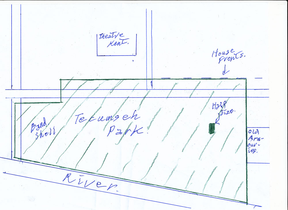
Map of Park with Cross marks showing area where shafts seem to exist.
Note the dark green area where I found a small area with half size "Marks".
Since there are spaces between them in 4 directions that would seem to rule out mechanical equipment.